You are using an outdated browser. Please upgrade your browser to improve your experience.
The IHM runs only in a Windows environment. Other system requirements depend on the size of the model being developed with the IHM and the desired speed at which simulations are desired to be completed. The following requirements and recommendations pertain to large regional models. IHM requires a 1.4 GHz or faster CPU processor but 2+ GHz is recommended and requires 4 GB RAM but 8 GB is recommended. A very large hard drive, preferable solid state, is recommended. For example a 10-year simulation covering 4,000 square miles with a modest level of spatial discretization takes almost 3 hours to complete and requires more than 50 GB of disk space. Refer to the IHM Installation Guide for more information.
Installation follows a recipe system. Due to the simplicity, there is no installation executable. The IHM Installation Guide provides a sequential set of instructions that are used to “install” the files. Most of the “install” requires copying files from a source drive to whatever PC you want to run it on. The IHM must be installed on a drive physically connected to the PC. Do not install it on a network drive or try to run simulations with input files stored on a network drive. The only install in the classic sense is when .Net Framework and SQL Local DB are installed which are both Microsoft products.
IHM software can be downloaded from the Product Releases page of the IHM website. You must be a registered user, which requires consenting to the IHM End User License Agreement, to download the IHM software.
Documentation for the IHM includes: IHM Theory Manual and appendices and IHM User Guide and appendices. Appendices of the Theory Manual include documentation of changes to HSPF and MODFLOW. Appendices of the User Guide include documentation for installation, the IHM example model, automated preprocessing for land and water features, postprocessing plugins, the IHM Programmer’s Guide, the IHM Data Dictionary, and the IHM utilities.
The IHM couples HSPF and MODFLOW in a sequential or asynchronous manner. The user specifies time step size for HSPF, IHM integration time step (≥ 1 day), and number of MODFLOW time steps within each stress period. The IHM forces the MODFLOW stress period length to be equal to the IHM integration time step.
Section 1 of the IHM Theory Manual summarizes the changes that were made to HSPF and MODFLOW which include communication links for integration and some hydrologic processes. More details are provided in the appendices of the Theory Manual.
The IHM simulation code is written in VB.net which couples HSPF and MODFLOW (component models) to perform all integrated hydrologic simulations. During a simulation, the IHM code is strictly used to read output from one of the component models and then to perform calculations which update parameters, and transfer flow, flux, and storage to the other component model.
An MS Access database is a core requirement for any IHM model application. The IHM input database stores a significant amount of input data and target (observations) time series data that are used for calibration. There is also input data in the standard HSPF uci files and the MODFLOW package files. The IHM produces many CSV output files for each simulation. The CSV output files are loaded to two MS Access databases – one most aligned with HSPF outputs (surface/vadose hydrology) and the other most aligned with MODFLOW outputs (groundwater hydrology). Two MS Access databases contain VBA code and embedded SQL statements which are used for automated preprocessing and postprocessing.
Two postprocessing plugins use a SQL Local DB database instead of MS Access. SQL Local DB is included in the Microsoft Office license but requires a separate download from Microsoft. Refer to the IHM Installation Guide.
One MS Access database contains VBA code and embedded SQL statements, which are used for automated preprocessing and contains links to tables in the input database.
One MS Access databases contains VBA code and embedded SQL statements, which are used for postprocessing and contains links to tables in the input and output databases. Other postprocessing plugins use VB.Net. All plugins require either an MS Access or a SQL Local DB database for inputs.
The IHM Theory Manual describes spatial and temporal discretization, integration paths, and capabilities and limitations in Section 1, hydrologic and integrated hydrologic processes in Section 2, and application of integrated processes in Section 3. The IHM User Guide describes folder and file structure and database design, data requirements and process steps for GIS operations, data input to the MS Access input database, and data input to standard files for HSPF and MODFLOW. The IHM automated preprocessing documentation will also be used to setup an IHM model.
Typically within 24 hours, but can be longer depending on staff availability.
Refer to the IHM User Guide. The IHM.log file is a helpful resource which is produced during a simulation. If an error message pops up with an HSPF label at the top of the window, take a screen shot of the text in the message (save as needed) and find the HSPF text output file (usually *.ech) within the HSPF folder. Search for “error” which should help to begin the troubleshooting process. If an error message pops up with a MODFLOW label at the top of the window, take a screen shot of the text in the message (save as needed) and find the MODFLOW text output file (usually *.out) within the MODFLOW folder. Search for “error” which should help to begin the troubleshooting process. Other output files are described in the User Guide which can also be helpful to discern the cause of simulation problems.
Refer to the IHM User Guide and any applicable appendix documents of the User Guide. Find applicable help by using the table of contents or by using an electronic search for a word or phrase.
Refer to the IHM User Guide and two appendix documents of the User Guide. Find applicable help by using the table of contents or by using an electronic search for a word or phrase.
Refer to the IHM User Guide and seven appendix documents, one for each plugin, of the User Guide. Find applicable help by using the table of contents or by using an electronic search for a word or phrase.
Integrated hydrologic modeling using an HSPF-MODFLOW coupled approach has been ongoing for almost 30 years. The IHM is the third generation of HSPF-MODFLOW coupling which began in the late 1980s. The FIPR Hydrologic Model (FHM) represented the first coupling of HSPF and MODFLOW which was developed by the University of South Florida and two consulting firms, BCI and SDI. The Integrated Surface Ground Water (ISGW) model was the second generation which coupled HSPF and MODFLOW which was adapted from the FHM and modified by SDI for larger scale model domains. Starting in the mid-1990s, the wholesale public water supply utility Tampa Bay Water began using the ISGW model for hydrologic investigations of wellfield pumping and surface-water withdrawals. In the late 1990s to early 2000s, external peer reviews of the ISGW model resulted in recommendations for significant modifications to the ISGW model to meet emerging objectives of Tampa Bay Water and the Southwest Florida Water Management District (SWFWMD), the regional water resources regulator in west-central Florida. Instead of modifying the ISGW, Tampa Bay Water and the SWFWMD partnered and collaborated in the early 2000s to create the IHM to meet the emerging objectives of each agency. The original development team for the IHM included two consulting firms, INTERA and Aqua Terra (now Respec), and the University of South Florida. Since the original IHM development, the agencies have continued to partner and collaborate to improve the IHM and to develop a calibrated model using the IHM which covers 4,000 square miles of west-central Florida. The calibrated model (INTB) was externally peer reviewed in 2013. The IHM code was peer reviewed in 2017. Completion of successful peer reviews and the expectation that others will find the IHM useful for decision support of water resources issues have prompted the agencies to offer the IHM for public use. More details about the history of the IHM are provided in Section 1 of the IHM Theory Manual.
- Review the following FAQs.
- Review or download the INTB Model Fact Sheet.
- Go to the Publications page of this website. Under the heading “Calibrated Model Applications using the IHM code”, use the links to download the INTB Model report and appendices and/or the INTB Model Peer Review report.
- After review of the written information, staff help can also be requested by using the help desk on this website.
The Integrated Northern Tampa Bay (INTB) hydrologic model provides an advanced, deterministic, physically-based tool which simulates all hydrologic processes and the dynamic interactions among coupled hydrologic processes. The INTB model has been developed, calibrated, and verified using the Integrated Hydrologic Model (IHM) code (Ross and Geurink 2017), which couples HSPF (surface water) and MODFLOW (groundwater). The calibration and verification periods spanned 10 years (1989 to 1998) and 8 years (1999 to 2006), respectively. Landuse is based on 1995 conditions. The INTB model domain covers 4,000 square miles and is located north and east of Tampa Bay in west-central Florida along the coast of the Gulf of Mexico. Tampa Bay Water and the Southwest Florida Water Management District (SWFWMD) cooperatively developed both the INTB model and the IHM code. The INTB model report and appendices provide a full description of the model and its development (Geurink and Basso 2013).
In the physical system of the INTB domain, feedback and interaction among coupled hydrologic processes begins when the depth-to-water table (DWT) is less than the groundwater evapotranspiration (GWET) extinction depth. The number of process feedback paths and the strength of the feedback increase as the water table moves closer to land surface (i.e., DWT approaches zero). Feedback and interaction among coupled hydrologic processes for water bodies is always present but becomes more dynamic when the DWT is less than the GWET extinction depth.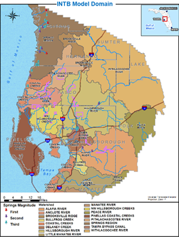
Hydrologic responses for coupled processes are exhibited for more than 50% of the INTB model domain where the DWT is less than 6 feet, at least during the wet season. Also, water bodies including lakes, wetlands, rivers, and floodplains cover 25% of the model domain. In some regions, water bodies cover more than 50% of the watershed area.
The groundwater system is comprised of a thin layer of unconsolidated deposits (surficial aquifer, SA) which overlays a semi-confining clay unit and a highly-transmissive carbonate aquifer (Upper Floridan aquifer, UFA). In the northern and southern portions of the domain, the UFA is unconfined and well confined, respectively. A significant degree of hydraulic interaction exists between the SA and UFA in the middle portion of the domain. Groundwater pumping from the UFA is significant and intense in some locations which influences recharge, ET, runoff, flow exchange between water bodies and groundwater (i.e., baseflow), and SA and UFA water levels.
The INTB model simulates the entire hydrologic system and dynamic feedbacks which are not simulated by single regime models. Variations in climate and anthropogenic stresses account for the total observed variability for flows and water levels, labeled the hydrologic response. Examples of anthropogenic stresses include landuse changes, groundwater pumping, and diversions to and from water bodies. Variability in climate (e.g., rainfall, solar radiation) causes natural variability in hydrologic responses. Change in landuse, groundwater pumping, and other anthropogenic factors cause additional variability in the hydrologic response. For many decision support issues, water resources managers require the dynamic and interactive variability in responses to be partitioned into separate contributions from climate and anthropogenic stresses. Field observations of flows and levels only provide the total change in flows and levels.
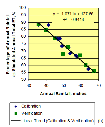
The INTB model provides the ability to separately partition the hydrologic influences of climate and anthropogenic stresses in the INTB region where more than 50% of the area exhibits coupled process responses that cannot be adequately simulated by single regime models. Simplified boundary conditions must be applied to models that simulate only surface water or groundwater processes (i.e., single regime models). These boundary conditions are linked to a specific limited range of inputs for both climate and anthropogenic stresses which limit the range of application of the single regime model for decision support in a region dominated by coupled process responses. The limiting boundary conditions for single regime models are replaced by dynamically-simulated coupled processes in the INTB model. The partitioned hydrologic responses are vital inputs to support decisions for operations, management, planning, and regulation of water resources systems.
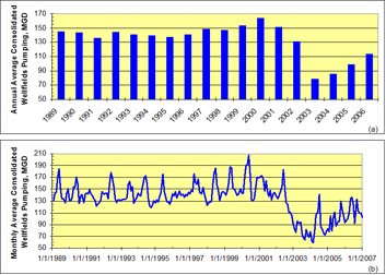
Starting in 2002, Tampa Bay Water began to reduce pumping from its 11 wellfields located in Pasco, Pinellas, and northern Hillsborough Counties (i.e., Consolidated Wellfields, CWF). Well pumping was reduced by 40% or 60 mgd and replaced by a combination of river and desalination sources. Since the cutback, a higher sustained mean condition is present for levels in the aquifers, lakes, and wetlands on and near the wellfields based on observed data. The INTB model reproduced well the observed data for aquifer levels and streamflow before, during, and after the cutback transition which occurred within the verification period of the model. Observed data and the INTB model indicate that depth-to-water table has decreased on and near the CWFs because of the cutback. Compared to a hypothetical case of using pre-2002 CWF pumping rates, the INTB model indicates that surface runoff and baseflow have also increased because of the decrease in depth-to-water table. Changes in streamflow, or its runoff and baseflow components, due to changes in well pumping are difficult to discern from observed data due to the combination of influences from climate and pumping. Combined influences can be partitioned by the INTB model which is a particular advantage of using this tool.
Temporal discretization is summarized in the following table.
| Model Code | Model Simulation Unit | Model Time Step | Description |
|---|---|---|---|
| HSPF | PERLND | 15 minutes | Pervious land segment hydrology |
| HSPF | IMPLND | 15 minutes | Impervious land segment hydrology |
| HSPF | RCHRES | daily | Reaches accounting for surface flow routing between water bodies and for all flows and storage for a water body |
| MODFLOW | Grid Cell | 3 steps each day using a logarithmic pattern | Main simulation unit for ground water accounting for all flows and storage |
| MODFLOW | Rivercell | 3 steps each day using a logarithmic pattern | Sub-cell feature with area equal to or less than the total cell area which simulates flow exchange between water bodies and ground water |
| IHM | All of the above, land and water-body fragments | daily | Within each integration time step (cycle), IHM facilitates integration or coupling for simulation units of all component models |
Spatial discretization is summarized in the following table.
| Model Simulation Unit | Simulation Unit Count | Description |
|---|---|---|
| Model Basin | 172 | Model basins are defined based on topographic flow divides. Basins are not used as simulation units but are used to discretize HSPF land segments and reaches. |
| HSPF: Surface Water | ||
| PERLND Forest Grass/Pasture Agric./Irrig. Mining/Other Urban |
815 172 172 164 138 169 |
Total of 815 pervious land segments divided among five generalized landuse classes. |
| IMPLND | 170 | One impervious land segment represents all imperviousness within each model basin. Two basins include zero impervious area. |
| RCHRES 1 Cond.-Connected Connected Routing |
409 172 163 74 |
Total of 409 reaches divided among three classifications based on surface-discharge connectivity and flow-through routing. |
| MODFLOW: Groundwater | ||
| Grid Cell | 207 x 183 (row x column) |
Number of active and constant head grid cells vary by model layer. |
| Model Layer | 3 | Total of three model layers representing: 1: surficial aquifer (SA); 2: intermediate confining unit and/or intermediate aquifer system (ICU/IAS); 3: Upper Floridan aquifer (UFA) |
| Rivercell SAS UFA Springs in UFA |
85,296 78,371 6,890 35 |
Total of 85,296 rivercells divided into connections to layers 1 & 3 for water bodies and a separate group for springs which discharge from the UFA. |
| IHM: Integration | ||
| Fragments Land Water-body |
167,011 82,391 84,620 |
Total of 167,011 IHM fragments divided into two groups. IHM uses fragments to communicate integration data between HSPF & MODFLOW. |
1 Conditionally-connected water bodies store water without surface discharge until the water level reaches a surface discharge threshold which is usually several feet above the bed.
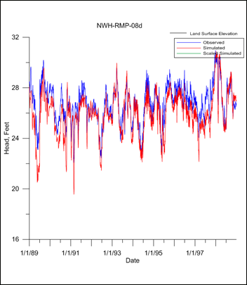
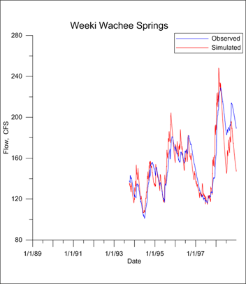 The INTB model was calibrated by manually adjusting model parameter values in an iterative manner to match target data using prior knowledge (information) within the model domain. After the INTB model was initially calibrated, the manual calibration process was guided by automatic parameter estimation analyses based on inverse modeling techniques using the parameter estimation software PEST (Parameter ESTimation, Watermark 2010). Model input parameters which depend on landuse and/or soils properties were defined by an area-weighting process. Property values were calibrated for landuse and soils at the detailed classification level which tied model input parameters to a physically-consistent spatial distribution across the model domain. Quantitative target data types and site count (in parenthesis) included: target ET by landuse and depth-to-water table, streamflow (38), springflow (7), SA wells (192), UFA wells (237), and hydraulic head difference from SA/UFA well pairs (129). Many types of qualitative target data were also employed to further constrain model parameters.
Evaluation statistics for the calibration included mean error, relative error, root mean squared error, mean absolute error, and Nash-Sutcliffe index. Model error was evaluated over the full range of data, over wet and dry quartiles, and above/below the median to discern model performance across the spectrum of wet to dry hydrologic conditions within which different hydrologic processes are active. Time series results from the model were evaluated at daily and sometimes weekly and monthly scales. The results were evaluated at several spatial scales.
The nature of a peer review is often to find the faults with the model and its application that the agencies could or should fix. However, at the outset, the Review Team would like to compliment the IHM program developers and those applying it to the INTB region. The Review Team feels that the INTB model was extremely well conceived, that the model made good use of the tremendous amount of available data, and that the final model was well calibrated. The Review Team congratulates everyone involved and believes that the model is well capable of handling the range of proposed applications within the limits of the model program and INTB model development.
 The INTB model is used to quantify individual and cumulative impacts on the hydrologic system caused by variations or changes in climatic (e.g., rainfall) and anthropogenic (e.g., pumping, land use) stresses. The model dynamically accounts for coupled hydrologic processes such as: determining the unit change in aquifer water levels caused by a unit change in groundwater pumping, evaluating well owner eligibility for mitigation of groundwater pumping impacts, evaluating water table and wetland impact/recovery as a result of groundwater pumping, simulating monthly streamflow, developing minimum flows and levels (MFL) for streams and springs and assessing the MFL status, evaluating potential changes in hydrology due to future climate change, evaluating feasibility options for direct or indirect use of reclaimed water as a supply source, and evaluating regulatory criteria for water use permitting and compliance. Several IHM-INTB model case studies are summarized with links to reports.
Geurink, J.S. and Basso, R. (2013). “Development, calibration, and evaluation of the Integrated Northern Tampa Bay Hydrologic Model.” Prepared for Tampa Bay Water and the Southwest Florida Water Management District, Clearwater, FL.
Ross, M.A. and Geurink J.S. (2018). “Integrated Hydrologic Model Version 3 Theory and Implementation.” Prepared for Tampa Bay Water, Clearwater, FL and the Southwest Florida Water Management District, Brooksville, FL.
WEST Consultants, Inc., Earthfx, Inc., and Hydrocomp, Inc. (2013). “Integrated Northern Tampa Bay Model Application Peer Review.” Prepared for Tampa Bay Water and the Southwest Florida Water Management District, Clearwater, FL.

