You are using an outdated browser. Please upgrade your browser to improve your experience.
Integrated Northern Tampa Bay Model
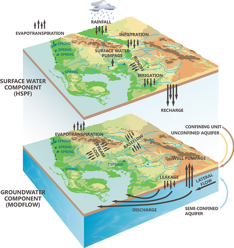
The Integrated Northern Tampa Bay (INTB) Model, a calibrated application of the Integrated Hydrologic Model code, encompasses 4,000 sqmi of west-central Florida. The model domain includes Tampa Bay and areas located east and north of Tampa Bay. The model was calibrated using 10 years of observed data for streamflow, springflow, aquifer water levels, and evapotranspiration target values for combinations of landuse and depth-to-water table.
The model was then verified for the succeeding eight years following the calibration period. Despite annual rainfall and groundwater pumping rates during the verification period being considerably higher or lower than the magnitudes used during the calibration period, model error remained small and very similar to error results of the calibration period. The INTB model has provided decision support for numerous water and land management decisions related to water supply planning and operations, regulation development, permitting, assessment of regulation compliance, and assessment of future hydrology related to potential future climates. An external peer review of the INTB model was completed in 2013.
In the following two panels: The video on the left compares calibrated and observed streamflow and springflow at all target locations. The video on the right compares calibrated and observed groundwater head at a subset of target locations.
Development and calibration of the INTB model was a joint effort of Tampa Bay Water and the Southwest Florida Water Management District. Click here to read/download report (153 MB)
Unit Responses Approach to Support Optimized Groundwater Pumping Operations
Tampa Bay Water is the largest wholesale provider of drinking water in the southeast U.S. The Integrated Northern Tampa Bay (INTB) Model, a calibrated application of the Integrated Hydrologic Model code, encompasses 4,000 square miles of west-central Florida including the service area of Tampa Bay Water.
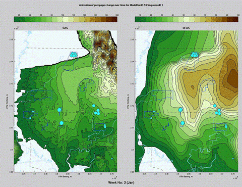
The INTB model was used to develop a unit response matrix (URM) that includes all wells within the Tampa Bay Water wellfields. An element of the URM represents the spatio-temporal change in aquifer water level (feet) per a unit change in well pumping rate (one MGD). The URM concept is similar to the unit hydrograph used in surface hydrology. For each Floridan aquifer (deep layer) production well, the pumping rate in the INTB model was perturbed by a unit pulse to determine the change in water level at the centroid of each INTB model grid cell for the surficial (shallow layer) and Floridan aquifers over a period of one and a half years. The URM is a very efficient way to compute changes in aquifer water levels resulting from changes to the temporal and spatial distribution of well pumping. It employs superposition methods by applying convolution integral on the combination of pumping rate changes and URM at all production wells to derive a new surface of aquifer water levels.
The method was shown to be valid and has been used to couple with an optimization routine for wellfield management program at Tampa Bay Water. The URM is used on a weekly basis to rotate well and wellfield pumping for the purpose of maximizing aquifer water levels relative to aquifer target controls that represent protective water levels for wetlands, lakes, and rivers. The URM was demonstrated to be linear and robust over a range of well pumping rate perturbations, pulsing durations, and seasonal initial conditions. Further investigation using stochastic rainfall realizations showed minor ensemble variation which confirmed the independency of the URM from rainfall. The ensemble median was used in the final development of the URM. In the animation to the left, weekly aquifer water level contours were interpolated from data at INTB model grid cells that were computed using URM. Click here to read/download report (1 MB)
Development of Minimum Flow for west-central Florida Rivers
The Southwest Florida Water Management District (SWFWMD) is responsible for protection of water resources within a 16 county region in west-central Florida along the coast of the Gulf of Mexico. Minimum flows and levels for rivers, springs, lakes, and wetlands are established as protective measures to prevent significant harm to the ecology and water resources of the area due to groundwater withdrawals.
The Integrated Northern Tampa Bay (INTB) Model, a calibrated application of the Integrated Hydrologic Model code, encompasses 4,000 square-mile area of west-central Florida including the central portion of the SWFWMD region. Within the groundwater basin that encompasses many rivers, wetlands, and lakes for which minimum flows and levels (MFLs) were required to be adopted, the INTB model was used to estimate aquifer water levels, streamflow, and springflow for a non-pumping condition by turning off all groundwater withdrawals in the groundwater basin. The difference in aquifer water levels, streamflow, or springflow rates between INTB simulations with recent pumping conditions compared to non-pumping conditions was defined as the estimate of impact due to withdrawals. The level and flow changes associated with groundwater withdrawal impacts were added to present-day observed levels and flows to define an unimpacted time series of aquifer levels, streamflow, and springflow. This times series of unimpacted flows or levels is called the baseline condition. MFLs are developed by determining an allowable reduction of the baseline conditions based on environmental criteria associated with significant harm. Click here to read/download report (6 MB)

Uncertainty of Minimum Flow for west-central Florida Rivers
Case Study 3 (above) describes how the Integrated Northern Tampa Bay (INTB) Model was used by the Southwest Florida Water Management District (SWFWMD) to estimate an unimpacted or baseline streamflow condition. Streamflow MFLs are developed by the SWFWMD after determining a percent reduction of the baseline flow conditions based on environmental criteria associated with significant harm at critical habitat thresholds in the channel and floodplain. The baseline flow condition was established using one 11-year historical period. An allowable temporal percent reduction in baseline conditions is a key factor in the determination of significant harm which pertains to the long-term persistence of flow at critical habitat thresholds. The SWFWMD has established that an MFL event is at least six years long.
Tampa Bay Water (TBW) was interested in quantifying how the baseline flow condition and the MFL are affected by streamflow uncertainty which is influenced by the interaction among climate variability, the hydrologic system, and anthropogenic stresses. Specifically, TBW was interested in quantifying input uncertainty for streamflow due to rainfall uncertainty and well pumping. Rainfall uncertainty is characterized by many key statistics representing the magnitude, temporal pattern, and spatial correlation of rainfall and the co-variance among those statistics. The range of probable magnitude for persistence of flow is significantly influenced by and is an outcome of rainfall uncertainty. Therefore, rainfall uncertainty is directly relevant to defining a streamflow MFL because the MFL depends on persistence of flow.
TBW implemented a numerical experiment to define the sample size required to capture the full uncertainty (probable range in magnitude and persistence) of streamflow. The Monte Carlo (MC) numerical experiment included running the INTB model 1000 times each for two well pumping scenarios using unique 20-year rainfall events that were stochastically derived from 60 or more years of historical rainfall data. The two well pumping scenarios matched those used by the SWFWMD to define the baseline flow condition for the MFL process. The 1000 INTB simulations produced 1000 possible baseline flow conditions that are equally probable to occur in the future.
For an MFL duration event, analysis of the MC results indicates that the minimum sample size required to capture the full streamflow uncertainty is 250 of the 1000 simulations. This is the equivalent of 1500 years of observed data.
When flows from the single 11-year historical period were compared to the MC results showing full streamflow uncertainty, flows during the historical period: (a) fell below the MC inter-quartile range for lower flow magnitudes (% exceedance < 20%) and (b) were at or above the MC inter-quartile range for higher flow magnitudes (% exceedance < 5%). These results clearly confirmed that the 11-year historical period represented a period of both wet and dry extremes which was known to the investigators through an external assessment before the experiment was run.
The numerical experiment indicates the range of probable streamflow persistence at this location, a key factor which established the physical and biological conditions at critical habitat thresholds over a long period of time (i.e., century or more), was not represented within the single 11-year historical period. Without accounting for streamflow uncertainty, an unachievable flow MFL could be established or the water resource could be under-utilized.

Assessment of future west-central Florida hydrology due to potential future climates
Tampa Bay Water has been collaborating with researchers from the Water Institute at the University of Florida and the Center for Ocean-Atmospheric Prediction Studies at Florida State University and other stakeholders under the umbrella of the Florida Water and Climate Alliance.
The Integrated Northern Tampa Bay (INTB) model has been used to assess the impact of climate change on the ability of Tampa Bay Water to provide water for its member governments. Some areas of research for future climates have included: 1) assessing impacts of changes in variability and magnitude of precipitation on streamflow and springflow and on water levels in aquifers, wetlands, and lakes, and 2) understanding impact of rising temperature on evapotranspiration and on all other significant water budget terms in the Tampa Bay region.
These INTB model scenarios used inputs for future climates that were driven by statistically and dynamically downscaled climate projections from Coupled Model Intercomparison Project (CMIP) 3 and 5 datasets using various emission scenarios. The downscaled products were specifically designed to incorporate unique features of central-Florida and Florida climatic conditions. Hydrologic responses produced by the INTB model using future climate inputs provided insights to better assess impacts that are unique to the Tampa Bay region that were not obvious by simply looking at only the downscaled precipitation and/or temperature outputs of General Circulation Models. Future climate scenarios should be coupled with a calibrated hydrologic simulation model that represents the region to assess future water resource and water supply conditions.
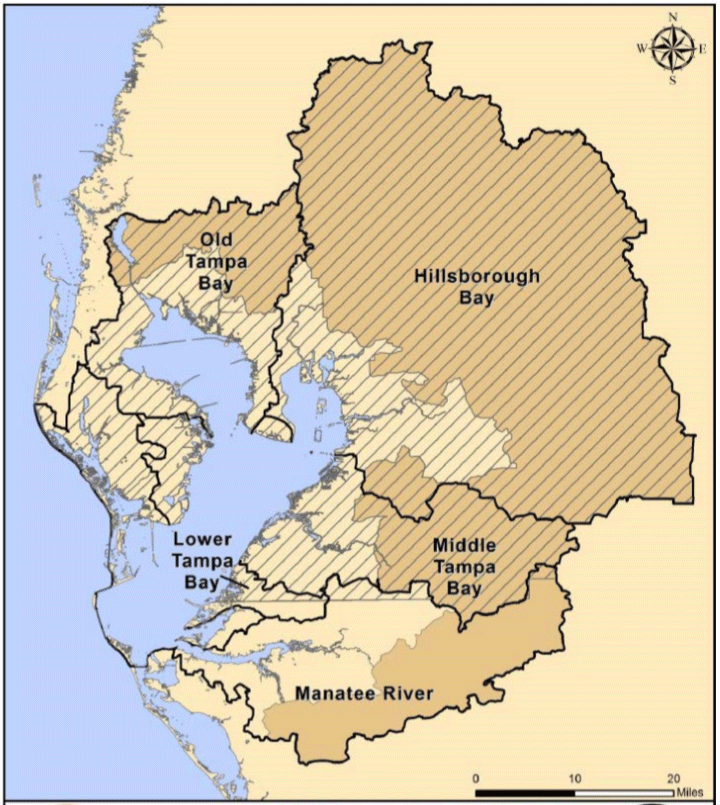
Assessment of Old Tampa Bay management scenarios
The Tampa Bay Estuary Program (TBEP) and the Southwest Florida Water Management District (SWFWMD) entered into a cooperative agreement to develop an integrated model system to evaluate potential management actions aimed at improving water quality, sediment conditions, and seagrass coverage extent in Old Tampa Bay (OTB). The OTB segment of Tampa Bay has been identified as an area of primary concern through several TBEP research initiatives and technical advisory committee recommendations. Unlike the other major bay segments of Tampa Bay, periodic poor water quality conditions, sediment accumulation, and limited seagrass expansion are still observed in OTB. The primary objectives of this project were to develop an integrated model system for the OTB estuarine system and drainage areas, and to use this system to predict and evaluate environmental responses that may result from the implementation of management actions represented in the model scenarios developed for this project. Given these objectives it became very clear that a mechanistic modeling approach was necessary to predict responses in the OTB to any of a series of potential management actions. The INTB model was used to provide freshwater flow inputs to the OTB. Also, the INTB model was modified to add capability to simulate water quality loading embedded within the freshwater flow to the OTB. An analysis of net environmental benefits and an assessment of relative costs was completed for various potential management actions. (summary taken from: Janicki, Inc. 2015. “Old Tampa Bay Integrated Model Development Project Executive Summary.” Prepared for the Tampa Bay Estuary Program). Click here to read/download report (5 MB)
Assessment of Scenarios with Zero Groundwater Pumping
The Southwest Florida Water Management District (SWFWMD) is responsible for protection of water resources within a 16 county region in west-central Florida along the coast of the Gulf of Mexico. Minimum flows for rivers and levels for lakes and wetlands are established by the SWFWMD as protective measures to sustain the ecologic and hydrologic functions of those systems. The SWFWMD used the INTB model to support development of minimum flows and levels (MFLs) with a scenario where all well pumping was turned off within a specific groundwater basin (see Case Study for Minimum Flow). An INTB model scenario, where all well pumping is turned off for a large region, is a significant deviation from groundwater stresses and hydrologic conditions that existed during the model calibration period. Relative to present-day availability of hydrologic observations, predevelopment observations are limited. An investigation of hydrologic responses for a zero well pumping INTB scenario was completed to understand how the INTB results could be used for decision making and furthermore, to identify any issues when interpreting the results. Click here to read/download report (18 MB)
Bayesian Radar Rainfall in West-Central Florida
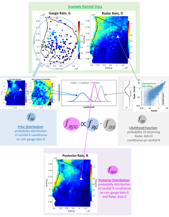
Spatial and temporal distributions of rainfall significantly impact surface water processes and the dynamic exchange between groundwater and surface water. Magnitude and distributions of rainfall also impact groundwater recharge. In west-central Florida, rain gauge records have been the primary source of historical rainfall data for water resources analyses and model development to support water management decision making. The Integrated Northern Tampa Bay (INTB) model, a calibrated application of the Integrated Hydrologic Model (IHM) code was originally developed using exclusively gauged rainfall.
Rainfall data derived from the Next Generation Radar (NEXRAD) data available since 1995 was expected to provide improved accuracy and resolution of the estimated historical rainfall from gauged records. However, an assessment of NEXRAD data revealed significant high bias for low magnitude daily rainfall and low bias for high magnitude daily rainfall compared to gauged rainfall. The assessment also revealed NEXRAD data low bias of 3 inches/year as a long-term average compared to gauged rainfall. These biases cause reduced water mass input to the simulated hydrologic system resulting in model parameterization that does not accurately represent the hydrologic system. A poorly- parameterized system can lead to decisions causing under or over-utilization of water resources, which is especially troublesome for a region that is already resource limited with large potential for growth in population and water demand.
To improve the accuracy and resolution of the estimated historical rainfall, a Bayesian statistical approach has been utilized to integrate the rain gauge data and rainfall data derived from NEXRAD. Rain gauge data were used to develop the prior distribution and radar rainfall uncertainty was used to derive a likelihood function. The resulting Bayesian radar rainfall accentuates the strengths of the rain gauge and radar data while de-emphasizing their weaknesses. Bayesian radar rainfall agrees with the gauged data at radar pixels co-located with gauges and is corrected for the radar rainfall biases. In addition, it reduces the uncertainty of the estimated rainfall.
Bayesian radar rainfall data and reports (GSI 2021a, b, c) documenting the data assessment and implementation processes are available for download using links at: integratedhydrologicmodel.org/Publications. Bayesian radar rainfall can be used for any application for which the original radar rainfall is used. These data are available for all or parts of west-central Florida counties including Citrus, Sumter, Lake, Hernando, Pasco, Polk, Pinellas, Hillsborough, Manatee, and Hardee for calendar years 1995 through 2019. Available resolution of Bayesian radar rainfall include:
- INTB model basins and daily time steps
- INTB model basins and 15-minute time steps
- 2 km pixels and 15-minute time steps